Lacey Green windmill is the oldest of its kind in the country. But do its origins lie here in Chesham?
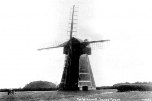
Most references to the windmill at Lacey Green (picture above), near Princes Risborough, including the Chesham history books by Clive Birch and George Piggin, state categorically that it was built in 1650 at Chesham, and stood here for its first 170 years. Apparently it was dismantled and removed to Lacey Green in 1821 by order of the Duke of Buckingham. But where is the evidence for this removal?
In fact it seems that the details were first recorded in 1932 by Donald Smith in his book English Windmills – Volume 2. He also noted the numbered timbers in the tower, indicating that it was dismantled and reassembled. It is now widely recognised that all timber structures were prefabricated and often parts were numbered before their assembly.
The original site for the windmill is claimed to be the grounds of Chesham’s long-gone Bury Hill House, on a mound known locally as ‘the rolling pin’ (picture below).
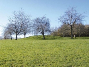
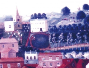
This is on the ridge at the top of Lowndes Park. The Chesham Town Picture, of c1760, shows a small structure on a mound at the top of the park (picture below). The painting uses much artistic licence, but it does look more like an architectural feature linked to the house.
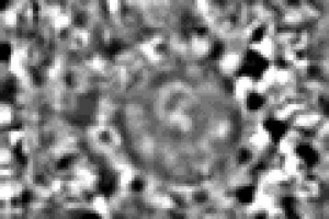
A few years ago the Chess Valley Archaeological & Historical Society (CVAHS) carried out a survey of the mound as part of The Festival of British Archaeology Week. It is a scheduled monument, so only a geophysical survey using a resistivity meter (measuring moisture with electrical resistance) was allowed. CVAHS tells us that the survey results (picture below) show a circular structure 22 metres in diameter enclosed by a thin partially complete darker coloured ring. This is interpreted as a narrow ditch surrounding the mound. The mound itself is indistinctive except for an intriguing ‘D’ shaped feature on its crest. It does exhibit many of the characteristics of a bowl barrow dating from the Neolithic period to the early Bronze Age (2400 – 1500 BC). These barrows tend to be found on higher ground and it is known that many were reused for other functions, including foundations for windmills.
Why wind when we have water?
In the 19th century, Chesham had at least five watermills on the River Chess. Water power is more reliable than wind power, raising the question as to whether a windmill would have been necessary. It would also have been a major undertaking to cart the huge wooden and metal machinery over 10 miles from Chesham, but such removals certainly took place elsewhere in the country.
The windmill was dated to 1650 by leading authority Stanley Freese, based on the design features of the machinery within. This makes it the oldest surviving smock mill in England (the term derives from its resemblance to an old man wearing a smock). Freese (1902-1972) lived at South Heath, near Great Missenden, and cycled all over the UK sketching and photographing mills. Among the books that he wrote were In Search of English Windmills in 1931, and Windmills and Millwrighting in 1957.
From 1971 the windmill was restored from a state of almost total collapse by volunteers from The Chiltern Society. Michael Highfield, author of the Society’s guide to the windmill, refers to a 96-year-old lady who had lived in Lacey Green all her life and remembered being chased away from ‘Cheshums Mill’ as a child. The windmill was run by the Cheshire family from 1863 to 1915 and the Buckinghamshire dialect may have caused this confusion.
Furthermore, the will of Peter Tyler of Loosley Row, dated March 1808, strongly suggests an earlier windmill on the Lacey Green site, although in theory this could have been destroyed and replaced.
James Venn, a retired lecturer and an old friend of Stanley Freese, points out that because mills were taxed there would have been a record of its existence in Chesham.
It would appear that sadly we may no longer be able to stake a claim to this historic landmark.
This article first appeared in Chesham Towntalk No 41 Autumn/Winter 2009.
It appears here with the kind permission of the author, Peter Hawkes, of
Hawkes Design & Publishing Ltd
59a The Broadway
High Street
Chesham
Bucks
HP5 1BX
;